26 September 2020, 8:04 PM
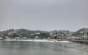
Significant snowfall to fairly low levels is almost certain around the south over the next few days, according to 45S Weather Services.MetService last night warned of a significant weather event for New Zealand, with heavy rain and severe gales for many places, and heavy snow possible in parts of the South Island. Warnings and watches are in force for much of the country.The culprit is an active and complex low pressure system is forecast to move east across New Zealand this weekend, bringing periods of heavy rain and gales to many places. AdvertisementAdvertise on the Southland AppMetService reports that, In the wake of this system, an unseasonably cold west to southwest flow should bring snow to low levels in western and southern parts of the South Island, possibly to near sea level in the far south.45S Weather Services further explains that a low, currently below about 976mbs, lies over Stewart Island and continues to deepen rapidly as it moves further southeast today, eventually reaching into the low 940's about 60S 178E. “That's a fair way southeast but of such magnitude that New Zealand and much of the Tasman will lie within its circulation for several days,” it says.“Very cold air is becoming entrained into this flow, ms2C currently at Macquarie and rule of thumb is that if it advects fairly directly in our direction, snow levels will reach near sea level when it's that cold there.” At 4pm today 45S Weather Services reported that despite sunny intervals enjoyed this afternoon, the weather would become less pleasant towards this evening, with showers more frequent near the coast and the ranges of Fiordland and western Southland, and this area continuing to be battered through the night.Temperatures were fluctuating up and down in showers and snow levels would be doing the same, with snow levels lowering slowly from about 700m to about 400m expected early this evening, then a drop to as low as 100m sometime before midnight, with some flurries possible to sea level by dawn.A surge in shower activity of the entire region is expected tomorrow as wind tends a little more directly southwest. Snowfalls are possible to sea level, with extensive snow cover likely above 100-200m.MetService also predicts large west to southwest swells from later today, affecting the west coasts of both islands, and the south and east coasts of central and southern New Zealand.The combination of snow and strong cold southwest winds is likely to cause disruption to traffic and stress to livestock. People are urged to take extra precautions, especially those travelling, and to stay up to date with the latest forecasts and warnings for their area as the event unfolds, the MetService says.AdvertismentAdvertise on the Southland AppA heavy rain watch has been in force for Fiordland for the 16 hours until 1pm today with periods of heavy rain predicted to lead to rainfall accumulations that may approach warning criteria.Similar warnings have been in place for the headwaters of the Otago lakes and rivers, valid for the 13 hours until 10am today.At 8.50am this morning, Environment Southland advised the Lill Burn at Lill Burn-Monowai Road was 1.06 metres above normal and rising 273 mm/hour.Snow is expected to lower to 300m in the Fiordland, Clutha, Central Otago south of Alexandra, and Southland areas, and then to near sea level during Monday morning, continuing through Tuesday. Snow accumulations may reach warning criteria above 300 metres.AdvertisementAdvertise on the Southland AppFor anyone planning travel, the following road snowfall warnings have been issued:Milford Road (SH94): A significant period of snow is expected. From 11am Sunday till 2pm Tuesday, around 50cm of snow may settle on the road, initially above 600 metres, but lowering to 200 metres Sunday evening, possibly even to sea level. Road closed from Park Boundary to Chasm. Gale winds affecting tree sections of road and heavy snowfall in avalanche terrain is forecast. That, along with disruptive snowfall to low levels forecast from Sunday to Tuesday means the road is closed from Hollyford Junction to the Chasm and will remain closed Sunday and Monday. The closure will extend to Park Boundary from 4pm this evening. Crown Range Road: Snow showers are expected to affect the road on Sunday and Monday. From 1pm Sunday till 3pm Monday, 10 to 15cm of snow may settle, initially above 700 metres, but lowering to 300 metres on Monday.Haast Pass (SH6): Snow is expected to affect the road from Sunday afternoon. From 3pm Sunday till 9am Monday, 15 to 25cm of snow may accumulate near the summit, with lesser amounts down to 300 metres overnight Sunday and Monday morning, possibly even lower. Note, further snow is likely after this period.Lindis Pass (SH8): Snow showers are expected to affect the road from Sunday afternoon. From 5pm Sunday till 6pm Monday, 8 to 12cm of snow may accumulate near the summit, with lesser amounts down to 300 metres overnight Sunday and on Monday.Lewis Pass (SH7): Snow showers are expected to affect the road from Sunday afternoon. From 5pm Sunday till 4am Tuesday, 15 to 20cm of snow may accumulate above 600 metres,with lesser amounts down to 400 metres on Monday and Tuesday.Arthur's Pass (SH73): Snow showers are expected to affect the road from Sunday afternoon. From 2pm Sunday till 4pm Monday, 10 to 15cm of snow may accumulate. Snow level about 800 metres at first, lowering to 300 metres overnight Sunday.45S Weather Services forecast for SouthlandMonday 28th: Showers become widespread everywhere with winds near gale on the coast and tending west-southwest. Hail, and snow possible to sea level.Tuesday 29th: Cold showery SW winds with hail and snow possible to sea level.Wednesday 30th: Cold SW winds slowly easing and tending westerly, showers lighter and less frequent and clearing inland by evening. Snow level rising above 700m by evening.Outlook: Fine in most places on Thursday, freshening but much milder NW winds on Friday with rain in Fiordland and some falls further east, snow level 2000m, westerly strengthen over the weekend with showery periods and snow may lower to 800m by Sunday.Milford Road at The Chapel, taken this morning. PHOTO: Milford Road Alliance