UPDATED: State Highway 6 closed from Five Rivers
02 January 2021, 3:09 AM

9.45pm UPDATE: SH6 between Five Rivers and Kingston has now reopened. A temporary 30km/hr speed restriction is in place at Fairlight, by Cainard Road. Caution is advised along this route.
Northbound traffic on State Highway 6 will now be stopped at Five Rivers, due to a road closure from Kingston.
Access will only be granted to road users being Five Rivers and Kingston.
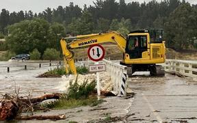
State Highway 6 has been closed between Frankton and Kingston since 1pm, due to flooding and slips. It's understood traffic has been backing up.
Motorists planning on travelling to or from Central Otago via the Devil's Staircase are being urged to avoid the area or delay their journey, if possible.
Waka Kotahi NZ Transport Agency reports several incidents of flooding and/or road washouts across the South Island.
Environment Southland has activated its flood warning system. The following situations existed as 9.24pm today:
- The Mataura River at Fairlight Station was 1.49 metres above normal and falling 40 mm/hour.
- The Mataura River at Cattle Flat was 1.92 metres above normal and rising 123 mm/hour.
- The Mataura River at Pyramid was 1.48 metres above normal and rising 70 mm/hour.
- The Waikaia River at Piano Flat was 3.5 metres above normal and falling 35 mm/hour.
- The Waikaia River at Waikaia was 2.65 metres above normal and rising 33 mm/hour.
- The Waikaia River at Mahers beach was 3.42 metres above normal and rising 262 mm/hour.
- The Oreti River at Lumsden Cableway was 2.48 metres above normal and rising 117 mm/hour.
- The Irthing Stream at Ellis Road was 2.07 metres above normal and rising 112 mm/hour.
- The Aparima River at Etalvale was 1.57 metres above normal and rising 45 mm/hour.
- The Hamilton Burn at Waterloo Road was 1.88 metres above normal and falling 87 mm/hour.
- The Lill Burn at Lill Burn-Monowai Road was 2.03 metres above normal and rising 134 mm/hour.
State Highway advisories
CLOSED
• SH1 Maheno to Reidston, Otago - FLOODING
• SH6 Frankton to Kingston, Otago - FLOODING & SLIPS
• SH87 Kyeburn to Outram, Otago - BRIDGE WASHOUT
OPEN- CAUTION
• SH82 Ikawai to Kurow, Canterbury - SURFACE FLOODING
• SH83 Kurow to Georgetown, Canterbury - SURFACE FLOODING