Snow forecast for late tomorrow

Paul Taylor
10 May 2021, 2:01 AM
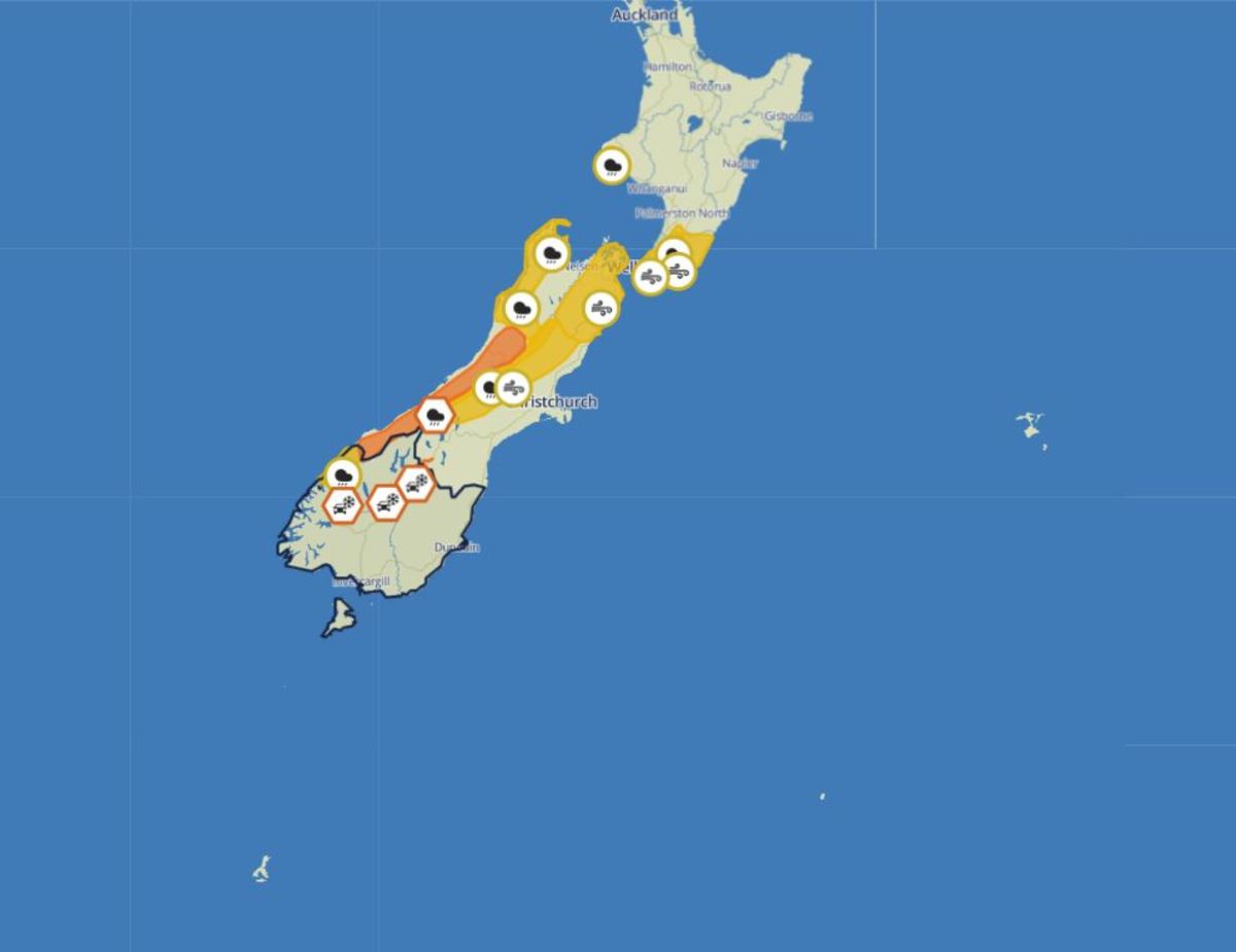 Image: MetService
Snow is expected to fall to around 600 metres in Southland, Dunedin and Southern Lakes tomorrow night due to an abrupt plunge in temperature.
The MetService is forecasting wintery and unsettled conditions across much of the South Island from late Tuesday onwards - with temperatures in some parts expected to drop my around 10 degrees Celsius.
It has issued a 'road snowfall warning' for the Milford Road (SH94) and a 'heavy rain watch' for Fiordland north of George Sound.
The Milford Road snow warning runs from 8pm tomorrow until 2am on Wednesday.
"Snow showers are likely from Tuesday evening to the early hours of Wednesday, and about 1cm of snow may settle on the road near the tunnel," the warning reads.
There are also snowfall warnings in place for the Crown Range Road between Queenstown and Wanaka and the Lindis Pass (SH8), with 1-2cm expected to settle near the tops of both over similar periods.
Before that, rainfall amounts may approach warning criteria in northern Fiordland.
A period of heavy rain expected between 4am and 3pm on Tuesday.
There are also 'heavy rain watches' in place for Buller, the ranges of northwest Nelson, the Tararua Range and Mount Taranaki.
Advertisement: Jumper Co

Advertise on the Southland App
Westland is expected to be the wettest place in the country. There is a 'heavy rain warning' (one level higher than a 'heavy rain watch') in place for Westland, where 120 to 180mm of rain to accumulate during this time. Peak rates of 20 to 30mm/h will occur during Tuesday morning.
In addition, 'strong wind watches' are in force for Canterbury High Country, Marlborough, Wellington and Wairarapa.
High temperatures cling on today (Monday) and most of Tuesday as a pulse of warmer air from the northwest washes over Aotearoa, with many centres expecting overnight temperatures in the mid to high teens.
However, a cold southerly change spreads up the South Island on Tuesday, and over the North Island on Wednesday.
"The difference will be most notable in the South Island, with a few locations set to see around a ten degree drop in temperature," MetService meteorologist Alwyn Bakker says.
"In particular, Christchurch is expected to reach 24C on Tuesday, just ahead of the change, but only 11C on Wednesday."
Check out the forecast and weather warnings on the MetService website.
AGENTS